Backpacking, Long Distance Hiking. Thru Hike of the Continental Divide Trail 2014
Wednesday, July 30, 2014
Steamboat Springs
Steamboat Springs is a great town to be stuck in. First of all they have a free bus system. We were able to get to Walmart, Safeway, and several other stops quite easily. Secondly, most of the restaurants downtown have happy hour specials so eating out is more affordable. I got a large pizza for $5 at dinner and will eat the leftovers for lunch. The downtown area has everything you need & don't need but one street behind the main drag is where the bike path along the river is. We have been staying at a great hotel called the Nordic Lodge. The owners have been super accommodating and understanding. The rooms are comfy and clean, the continental breakfast is one of the best I've seen, and they have a pool & hot tub. So we've had a nice stat but the weather continues to be nasty and I'm beginning to wonder if we will ever get out of Colorado. On the positive side though if we'd been able to hike out we'd be stuck in Lander over the weekend waiting for the post office to open on Mon. So... let it pour I guess!
Monday, July 28, 2014
Corrections
We did not get all of the way to Steamboat Springs yesterday. We camped off of the road. We waited for the rain to stop to set up our tents. Today we hiked the rest of the dirt county road and paved roads to where we hitched to Steamboat. We were picked up pretty quickly and dropped off at the visitors center. It's really been interesting doing all of this hitchiking because we meet so many different people and get a glimpse of their lives.
So a few mantras and themes have emerged for this hike. They are: 1) steady plodding, 2) take it as it comes, 3) it is what it is 4) suck it up cupcake. This last one comes from Hikeaholic. The weather forecast is pretty bad the next two days. A special hazardous report issued for heavy rain, thunderstorms with cloud to ground lightning, mudslides and flooding. So we are trying to come up with a plan.
Sunday, July 27, 2014
Out of the Mountains
We've been in the Rabbit Ears Range. These mountains are more green and rocky with spires, cliffs, and other formations. Today we had 20 miles of exposure but it wasn't as steep and trees were easier to get to. However we were still hiking fast with our eyes to the sky and not taking breaks. But the weather held. It held til 5 pm when we got hammered by a couple of storms. By then we had descended out of the mountains and had plenty of tree cover during the worst of it. We hiked on forest service roads and paved roads to near Rabbit Ears pass. From there we hitched into Steamboat Springs. I was so ready for a hotel we splurged on a nice one with a hot tub. A friend of Pounces is on a road trip and happened to be in Steamboat same time as us. Perfect timing! So we are all hanging out and enjoying the downtime. Whew, what an intense few days!
Epic
Today started out well and we made great progress in the morning. As there often is, the route split into a high and low route. The official CDT was high and much shorter. Since the weather was good we stayed on the CDT.
We ate lunch at treeline and checked the sky for storms. It still looked good. So we climbed up Parkview mountain but fifteen hundred feet of elevation gain in one mile is steep! What made it even more challenging was there was no track and a lot of loose rock and talus. Needless to say it took awhile. I had just reached the summit and sat down to rest when Pounce said "Look, we have to go down now!" A thunderstorm had popped up and was coming our way. We ran down the mountain to a saddle and then down off the side to some trees. We got there just as it started raining, put on rain gear and huddled til it passed. The sun came out along with blue sky, so we climbed back to the trail. Five minutes later we were running down the other side of the saddle to tree cover to wait out another storm cell. Sun and blue sky again, back to the saddle and more storms. There was no way we could continue on trail above treeline, nor could we stay where we were as there was no place to pitch a tent. So we did a cross country route that followed a drainage off of the saddle. A cross country in the Rockies is crazy! It was steep, slippery and wet. When the blow downs and brush were too much we walked in the creek or crossed to the other side. When that didn't work we climbed above it. We crossed a ravine and another creek as we worked our way around the mountain and then up towards haystack mountain on the other side. Thunderstorms kept rolling through all the while and raining on us but we were protected in the trees. It was such a relief when we regained the trail. I could have knelt down and kissed it. Looking back we could see there was still weather on the ridge. We would've been stuck if we'd stayed. Our destination was Troublesome pass and it sure lived up to its name. We made it though.
Feeling Good
We walked all of a mile through Rocky Mountain National Park to a visitor center. Then goodbye to the park and walk ATV roads up to Blue Ridge. It was gorgeous on the ridge and made a nice evening walk. This was the high route which was seven miles shorter and since the weather was cooperating we went for it. We got a text message from Hikeaholic that he'd accidentally mailed his gps home so we left him arrows and cairns at all of the road intersections. I feel good about the next few days. There are a couple of big climbs but overall the elevation profile is easier.
We found some antlers with the fuzz worn off so we both had to take pictures with it, being silly.
Saturday, July 26, 2014
Grand Lake
The CDT runs right through Grand Lake on the edge of Rocky Mountain National Park. It's signed and everything. We met up with Hikeaholic and after resupplying at the grocery store, walked through town to the Shadowcliff Lodge. The lodge sits high on a bluff overlooking the lake and town. It's quite large and is a retreat of sorts with workshops & such. It has a very peaceful vibe. We are staying in the hostel part. I had fun playing tourist today, checking out the shops, getting pizza, and even eating ice cream. Here's Pounce and Hikeaholic walking to downtown. It's a nice town and it would be great to spend more time here but after a zero in both Leadville and Silverthorne we can't.
Wednesday, July 23, 2014
Miles & an Angel
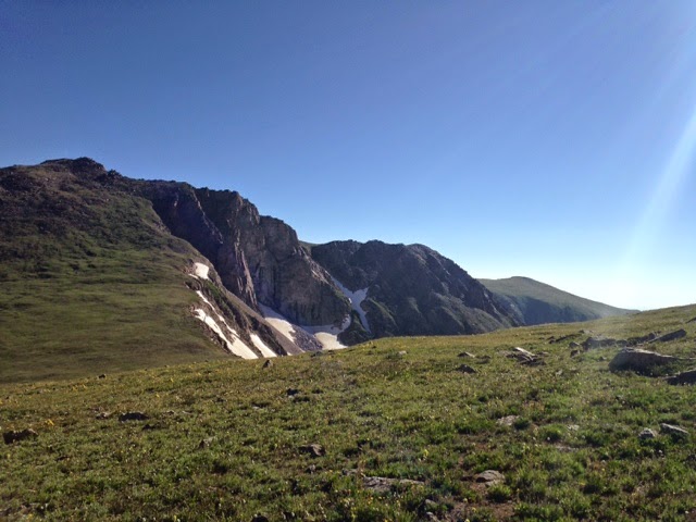
Reflecting back on last night coming down the mountain, the trees were welcoming us with open branches. They invoked a sense of calm and serenity after the harshness of the mountain peaks we had climbed. And yet those same mountains were breathtakingly spectacular. We climbed back up into them on a forest service road that used to be a railroad. Rollins pass at the top was the site of a restaurant and lodge back in the early 1900s. It's long been abandoned but we could see remnants of the foundation. It was a beautiful morning for hiking and we enjoyed our last bit of above tree line views and then it was a long descent down. And down, and down. It was flat to gently rolling trail through meadows, marshes and forest and then down some more. We came out at Monarch Lake and stopped at a campground to cook dinner before hiking further. Hikeaholic was ahead of us down the trail and he called me (yes called) and reported the blow downs were just as bad or worse then reported by others. However, he saw a lot of moose. So we elected to walk around Arapahoe lake on the opposite side of the trail along the road. We had walked 30 miles and it was getting dark. Our plan was to camp in the trees somewhere out of sight. A car passed us and then turned around and came back. She said "it gets dark here a lot quicker than you think. Can I give you a ride somewhere. Well, by this time we'd walked most of the dirt road portion so we accepted. We asked to be dropped at a campground ahead but she asked if we wanted a shower and invited us to spend the night at her cabin nearby.
I'm so glad we did. This lady was in her 70s and had traveled all over the work. She understood intuitively what we needed and what we were doing. She was amazing and fun to talk too. We stayed up late sitting on her deck talking and looking up at the stars.
Subscribe to:
Posts (Atom)